
Mapa topográfico Plattkofel
Mapa interativo
Clique no mapa para exibir a altitude.
Sobre este mapa
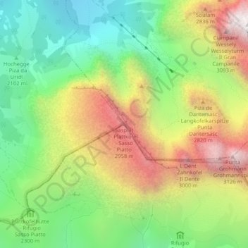
Nome: Mapa topográfico Plattkofel, altitude, relevo.
Altitude média: 2.395 m
Altitude mínima: 1.831 m
Altitude máxima: 3.160 m
Der Plattkofel ist der westlichste Berg der Langkofelgruppe zwischen Gröden in Südtirol und dem Fassatal im Trentino. Während die namengebende Westflanke recht ebenmäßig und verhältnismäßig flach zum Gipfelgrat ansteigt, bricht die Ostflanke unvermittelt steil zum Plattkofelkar ab. Der grob in Nordwest-Südost-Richtung verlaufende Gipfelgrat weist drei Gipfelpunkte auf. Der touristisch bedeutendste ist der über markierte Steige erreichbare Mittelgipfel (2958 m) mit einem Gipfelkreuz. Der höchste Punkt des Bergs findet sich jedoch am Südostgipfel mit einer Höhe von 2964 m, während der Nordwestgipfel eine Höhe von 2954 m aufweist.
Outros mapas topográficos
Clique em um mapa para visualizar sua topografia, sua altitude e seu relevo.
Langkofel
Italien > Trentino-Südtirol > Bozen > St. Christina in Gröden
Langkofel, St. Christina in Gröden, Salten-Schlern, Bozen, Trentino-Südtirol, 39048, Italien
Altitude média: 2.320 m
Langkofel
Italien > Trentino-Südtirol > Bozen > St. Christina in Gröden
Langkofel, St. Christina in Gröden, Salten-Schlern, Bozen, Trentino-Südtirol, 39048, Italien
Altitude média: 2.322 m