
Mapa topográfico Cross Stone
Clique no mapa para exibir a altitude.
Sobre este mapa
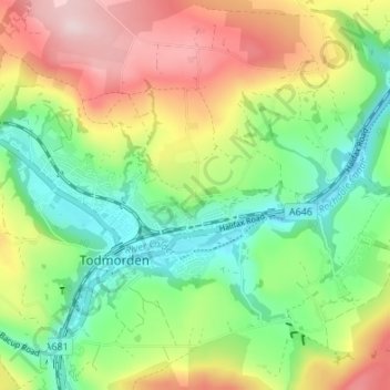
Nome: Mapa topográfico Cross Stone, altitude, relevo.
Altitude média: 245 m
Altitude mínima: 115 m
Altitude máxima: 437 m
Outros mapas topográficos
Clique em um mapa para visualizar sua topografia, sua altitude e seu relevo.
Ragby Plantation
United Kingdom > England > Calderdale > Todmorden > Walsden > Bottoms
Altitude média: 293 m
Gaddings Dam
United Kingdom > England > Calderdale > Todmorden > Walsden
Gaddings Dam is a locally owned reservoir near to Todmorden in West Yorkshire, England. The dam was built to power water mills in the Todmorden area, being superseded by steam power and left redundant. It is notable for having a sandy beach at the north-eastern side which attracts people to it during the…
Altitude média: 283 m