
Obrigado por apoiar este site ❤️
Faça uma doação
Faça uma doação
Mapa topográfico Landeck
Clique no mapa para exibir a altitude.
Obrigado por apoiar este site ❤️
Faça uma doação
Faça uma doação
Landeck
Landeck is located in the Tyrolean Oberland in the west of the state at an elevation of about 820 m (2,690 ft). The town is situated in the valley of the Inn River at the confluence with the Sanna tributary, between the Lechtal Alps, part of the Northern Limestone Alps in the north, and the Ötztal Alps and Samnaun Alps ranges of the Central Eastern Alps in the south.
Obrigado por apoiar este site ❤️
Faça uma doação
Faça uma doação
Sobre este mapa
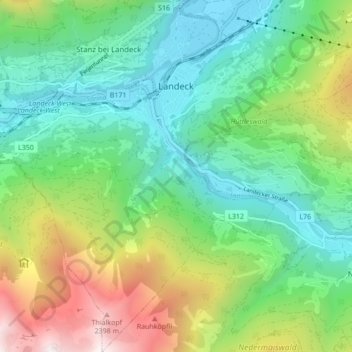
Nome: Mapa topográfico Landeck, altitude, relevo.
Local: Landeck, Bezirk Landeck, 6500, Austria (47.09818 10.52642 47.15665 10.60537)
Altitude média: 1.325 m
Altitude mínima: 764 m
Altitude máxima: 2.582 m
Obrigado por apoiar este site ❤️
Faça uma doação
Faça uma doação
Outros mapas topográficos
Clique em um mapa para visualizar sua topografia, sua altitude e seu relevo.