
Obrigado por apoiar este site ❤️
Faça uma doação
Faça uma doação
Mapa topográfico Castellgalí
Clique no mapa para exibir a altitude.
Obrigado por apoiar este site ❤️
Faça uma doação
Faça uma doação
Castellgalí
Castellgalí liegt in einer Höhe von etwa 265 m auf dem Westufer des Riu Llobregat, in den hier der Cardener mündet, in der Kulturlandschaft Pla de Bages. Barcelona liegt etwa 50 Kilometer südöstlich.
Obrigado por apoiar este site ❤️
Faça uma doação
Faça uma doação
Sobre este mapa
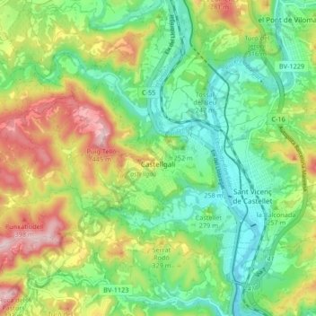
Nome: Mapa topográfico Castellgalí, altitude, relevo.
Local: Castellgalí, Bages, Barcelona, 08297, Spanien (41.65291 1.78719 41.69598 1.86986)
Altitude média: 257 m
Altitude mínima: 150 m
Altitude máxima: 438 m
Obrigado por apoiar este site ❤️
Faça uma doação
Faça uma doação