
Mapa topográfico Bodeghem-Saint-Martin
Mapa interativo
Clique no mapa para exibir a altitude.
Sobre este mapa
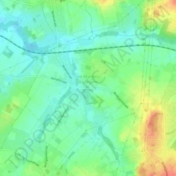
Nome: Mapa topográfico Bodeghem-Saint-Martin, altitude, relevo.
Altitude média: 40 m
Altitude mínima: 22 m
Altitude máxima: 74 m
Outros mapas topográficos
Clique em um mapa para visualizar sua topografia, sua altitude e seu relevo.
Dilbeek
Belgique > Brabant flamand > Hal-Vilvorde > Dilbeek
Dilbeek, Hal-Vilvorde, Brabant flamand, Flandre, 1700, Belgique
Altitude média: 52 m