
Mapa topográfico Bellinzona
Mapa interativo
Clique no mapa para exibir a altitude.
Sobre este mapa
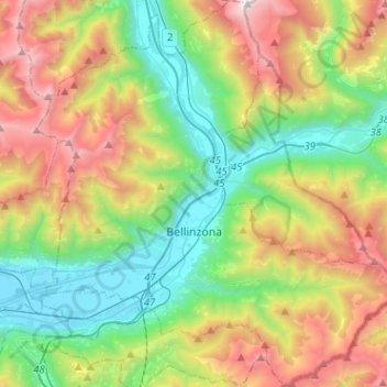
Nome: Mapa topográfico Bellinzona, altitude, relevo.
Altitude média: 1.083 m
Altitude mínima: 195 m
Altitude máxima: 2.682 m
Bellinzona is situated in the valley of the river Ticino, at an altitude of 240 metres (790 ft). The town centre lies about 1 kilometre (0.62 mi) east of the river, with the urban area confined to the bottom and lower slopes of the valley. However the municipality's boundaries extend up both sides of the valley, to altitudes of 2,240 metres (7,350 ft) to the west, and 2,195 metres (7,201 ft) to the east.
Outros mapas topográficos
Clique em um mapa para visualizar sua topografia, sua altitude e seu relevo.
Sementina
Switzerland > Ticino > Distretto di Bellinzona > Bellinzona
Sementina, Bellinzona, Circolo di Bellinzona, Distretto di Bellinzona, Ticino, 6514, Switzerland
Altitude média: 381 m