
Mapa topográfico Linkerskopf
Mapa interativo
Clique no mapa para exibir a altitude.
Sobre este mapa
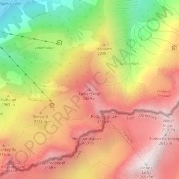
Nome: Mapa topográfico Linkerskopf, altitude, relevo.
Altitude média: 1.995 m
Altitude mínima: 1.149 m
Altitude máxima: 2.624 m
Outros mapas topográficos
Clique em um mapa para visualizar sua topografia, sua altitude e seu relevo.
Schochen
Deutschland > Bayern > Landkreis Oberallgäu > Oberstdorf
Schochen, Oberstdorf, Landkreis Oberallgäu, Bayern, Deutschland
Altitude média: 1.643 m
Trettach
Deutschland > Bayern > Landkreis Oberallgäu > Oberstdorf
Trettach, Oberstdorf, Landkreis Oberallgäu, Bayern, Deutschland
Altitude média: 1.469 m
Söllereck
Deutschland > Bayern > Landkreis Oberallgäu > Oberstdorf
Söllereck, Oberstdorf, Landkreis Oberallgäu, Bayern, Deutschland
Altitude média: 1.339 m
Schlappolt
Deutschland > Bayern > Landkreis Oberallgäu > Oberstdorf
Schlappolt, Laiter, Oberstdorf, Landkreis Oberallgäu, Bayern, 87561, Deutschland
Altitude média: 1.587 m
Tiefenbach
Deutschland > Bayern > Landkreis Oberallgäu > Oberstdorf > Tiefenbach
Tiefenbach, Oberstdorf, Landkreis Oberallgäu, Bayern, 87561, Deutschland
Altitude média: 971 m
Gottenried
Deutschland > Bayern > Landkreis Oberallgäu > Oberstdorf > Gottenried
Gottenried, Oberstdorf, Landkreis Oberallgäu, Bayern, Deutschland
Altitude média: 1.288 m
Stillachtal
Deutschland > Bayern > Landkreis Oberallgäu > Oberstdorf
Stillachtal, Oberstdorf, Landkreis Oberallgäu, Bayern, 87561, Deutschland
Altitude média: 1.363 m
Hirschegg
Deutschland > Bayern > Landkreis Oberallgäu > Oberstdorf
Hirschegg, Oberstdorf, Landkreis Oberallgäu, Bayern, Deutschland
Altitude média: 1.594 m
Hochfrottspitze
Deutschland > Bayern > Landkreis Oberallgäu > Oberstdorf
Hochfrottspitze, Oberstdorf, Landkreis Oberallgäu, Bayern, Deutschland
Altitude média: 2.109 m
Kornau
Deutschland > Bayern > Landkreis Oberallgäu > Oberstdorf
Kornau, Oberstdorf, Landkreis Oberallgäu, Bayern, 87561, Deutschland
Altitude média: 964 m
Schöllang
Deutschland > Bayern > Landkreis Oberallgäu > Oberstdorf
Schöllang, Oberstdorf, Landkreis Oberallgäu, Bayern, 87538, Deutschland
Altitude média: 966 m
Musberg
Deutschland > Bayern > Landkreis Oberallgäu > Oberstdorf
Musberg, Oberstdorf, Landkreis Oberallgäu, Bayern, Deutschland
Altitude média: 1.375 m
Trettachspitze
Deutschland > Bayern > Landkreis Oberallgäu > Oberstdorf
Trettachspitze, Oberstdorf, Landkreis Oberallgäu, Bayern, Deutschland
Altitude média: 2.045 m