
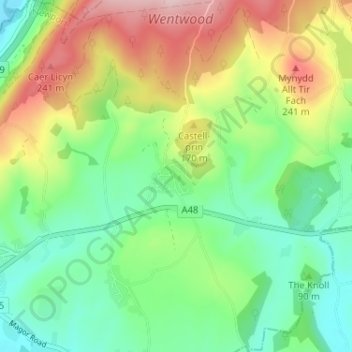
Mapa topográfico Parc Seymour
Mapa interativo
Clique no mapa para exibir a altitude.
Sobre este mapa
Nome: Mapa topográfico Parc Seymour, altitude, relevo.
Altitude média: 107 m
Altitude mínima: 5 m
Altitude máxima: 284 m
Outros mapas topográficos
Clique em um mapa para visualizar sua topografia, sua altitude e seu relevo.
Monmouthshire Canal Crumlin Branch
United Kingdom > Wales > Gwent > Newport
Monmouthshire Canal Crumlin Branch, Barrack Hill, Allt-Yr-Yn, Newport, Gwent, Wales, NP20 5EH, United Kingdom
Altitude média: 40 m
Monmouthshire Canal Crumlin Branch
United Kingdom > Wales > Gwent > Newport
Monmouthshire Canal Crumlin Branch, Ridgeway, Allt-Yr-Yn, Newport, Gwent, Wales, NP20 5DX, United Kingdom
Altitude média: 43 m
Underwood
United Kingdom > Wales > Gwent > Newport
Underwood, Newport, Gwent, Wales, NP18 2HQ, United Kingdom
Altitude média: 38 m
Malpas
United Kingdom > Wales > Gwent > Newport
Malpas, Newport, Gwent, Wales, United Kingdom
Altitude média: 30 m
Rhiwderin
United Kingdom > Wales > Gwent > Newport
Rhiwderin, Newport, Gwent, Wales, NP10 8RN, United Kingdom
Altitude média: 73 m