
Faça uma doação
Mapa topográfico Oakhurst
Clique no mapa para exibir a altitude.
Faça uma doação
Oakhurst
Oakhurst (formerly Fresno Flats) is a census-designated place (CDP) in Madera County, California, United States, 14 miles (23 km) south of the entrance to Yosemite National Park, in the foothills of the Sierra Nevada. At an elevation of 2,274 ft (693 m), Oakhurst is situated at the junction of Highway 41 and Highway 49, marking the southern end of California's Gold Country. It is part of the Madera metropolitan statistical area.
Faça uma doação
Sobre este mapa
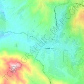
Nome: Mapa topográfico Oakhurst, altitude, relevo.
Local: Oakhurst, Madera County, California, 93644, United States (37.29934 -119.67189 37.36699 -119.61735)
Altitude média: 837 m
Altitude mínima: 644 m
Altitude máxima: 1.385 m
Faça uma doação
Outros mapas topográficos
Clique em um mapa para visualizar sua topografia, sua altitude e seu relevo.