
Mapa topográfico Macreddin
Clique no mapa para exibir a altitude.
Macreddin
The elevation of Carysfort was too high and settlers soon moved south down the valley to Aughrim. In the eighteenth century there was still a fairground at the crossroads, with "riotous" two-day fairs held at Whitsun and All Saints. Michael Dwyer stayed in Macreddin when repairing to the Wicklow Mountains after the 1798 Rising. The 1835 commissioners' report described Carysfort as "a small village, containing a few houses of the humblest class", and concluded, "There is but a thinly-scattered population in the neighbourhood, and neither trade or commerce of any kind in the village, and there seems to be no occasion whatever for reviving the corporation."
Sobre este mapa
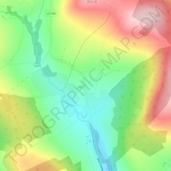
Nome: Mapa topográfico Macreddin, altitude, relevo.
Altitude média: 224 m
Altitude mínima: 108 m
Altitude máxima: 374 m
Outros mapas topográficos
Clique em um mapa para visualizar sua topografia, sua altitude e seu relevo.
Baltinglass
A nineteenth-century explanation is found in Samuel Lewis' A Topographical Dictionary of Ireland, where he says that the name, "according to most antiquaries," comes from Baal-Tin-Glas, meaning the "pure fire of Baal," and that this suggests that the area was a centre for "druidical worship".
Altitude média: 163 m