
Obrigado por apoiar este site ❤️
Faça uma doação
Faça uma doação
Mapa topográfico Truro
Clique no mapa para exibir a altitude.
Obrigado por apoiar este site ❤️
Faça uma doação
Faça uma doação
Truro
Truro (postcode 5356, altitude 311m) is a town in South Australia, 80 km northeast of Adelaide. It is situated in an agricultural and pastoral district on the Sturt Highway, east of the Barossa Valley, where the highway crosses somewhat lofty and rugged parts of the Mount Lofty Ranges. At the 2021 census, Truro had a population of 523.
Obrigado por apoiar este site ❤️
Faça uma doação
Faça uma doação
Sobre este mapa
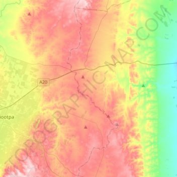
Nome: Mapa topográfico Truro, altitude, relevo.
Altitude média: 320 m
Altitude mínima: 121 m
Altitude máxima: 518 m
Obrigado por apoiar este site ❤️
Faça uma doação
Faça uma doação
Outros mapas topográficos
Clique em um mapa para visualizar sua topografia, sua altitude e seu relevo.