
Mapa topográfico Ottweiler
Mapa interativo
Clique no mapa para exibir a altitude.
Sobre este mapa
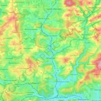
Nome: Mapa topográfico Ottweiler, altitude, relevo.
Local: Ottweiler, Landkreis Neunkirchen, Saarland, 66564, Germany (49.38435 7.09076 49.44109 7.29285)
Altitude média: 329 m
Altitude mínima: 236 m
Altitude máxima: 513 m
Outros mapas topográficos
Clique em um mapa para visualizar sua topografia, sua altitude e seu relevo.
Neunkirchen
Germany > Saarland > Landkreis Neunkirchen > Neunkirchen
Neunkirchen, Landkreis Neunkirchen, Saarland, 66538, Germany
Altitude média: 280 m
Eppelborn
Germany > Saarland > Landkreis Neunkirchen
Eppelborn, Landkreis Neunkirchen, Saarland, 66571, Germany
Altitude média: 297 m
Illingen
Germany > Saarland > Landkreis Neunkirchen
Illingen, Landkreis Neunkirchen, Saarland, 66557, Germany
Altitude média: 331 m
Schiffweiler
Germany > Saarland > Landkreis Neunkirchen
Schiffweiler, Landkreis Neunkirchen, Saarland, 66578, Germany
Altitude média: 314 m