
Mapa topográfico Warrior
Mapa interativo
Clique no mapa para exibir a altitude.
Warrior
Warrior is in the Central time zone. The elevation at the center of town is 564 feet (172 m), though it ranges from over 620 feet (190 m) north of the center to less than 300 feet (91 m) along the Locust Fork of the Black Warrior River, which forms the southern boundary of the city.
Sobre este mapa
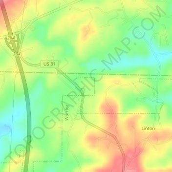
Nome: Mapa topográfico Warrior, altitude, relevo.
Local: Warrior, Jefferson County, Alabama, United States (33.83861 -86.81552 33.84150 -86.81154)
Altitude média: 149 m
Altitude mínima: 107 m
Altitude máxima: 193 m