
Faça uma doação
Mapa topográfico Whitworth
Clique no mapa para exibir a altitude.
Faça uma doação
Sobre este mapa
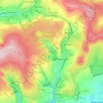
Nome: Mapa topográfico Whitworth, altitude, relevo.
Altitude média: 317 m
Altitude mínima: 159 m
Altitude máxima: 477 m
Faça uma doação
Outros mapas topográficos
Clique em um mapa para visualizar sua topografia, sua altitude e seu relevo.
Bacup
United Kingdom > England > Lancashire > Borough of Rossendale
The geology and topography of the village lent itself to urbanisation and domestic industries; primitive weavers' cottages, coal pits and stone quarries were propelled by Bacup's natural supply of water power in the Early Modern period. The adoption of the factory system, which developed into the Industrial…
Altitude média: 337 m
Haslingden Grane
United Kingdom > England > Lancashire > Borough of Rossendale > Haslingden
Altitude média: 287 m
Faça uma doação
Irwell Springs
United Kingdom > England > Lancashire > Borough of Rossendale > Weir
Altitude média: 365 m
Faça uma doação
Clowbridge
United Kingdom > England > Lancashire > Borough of Rossendale > Habergham Eaves
Altitude média: 319 m
Whitewell Bottom
United Kingdom > England > Lancashire > Borough of Rossendale > Sagar Holme
Altitude média: 281 m
Fold Head
United Kingdom > England > Lancashire > Borough of Rossendale > Healey
Altitude média: 294 m
Faça uma doação
Trough Gate
United Kingdom > England > Lancashire > Borough of Rossendale > Britannia
Altitude média: 341 m
Forest Holme
United Kingdom > England > Lancashire > Borough of Rossendale > Water
Altitude média: 318 m
Nun Hills
United Kingdom > England > Lancashire > Borough of Rossendale > Stacksteads
Altitude média: 316 m
Faça uma doação
Cowm Reservoir
United Kingdom > England > Lancashire > Borough of Rossendale > Whitworth > Shawforth
Altitude média: 302 m
Rake Head
United Kingdom > England > Lancashire > Borough of Rossendale > Stacksteads
Altitude média: 315 m
Faça uma doação