
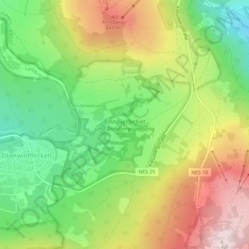
Mapa topográfico Sinnquellgebiet und Arnsbergsüdhang
Mapa interativo
Clique no mapa para exibir a altitude.
Sobre este mapa
Nome: Mapa topográfico Sinnquellgebiet und Arnsbergsüdhang, altitude, relevo.
Altitude média: 697 m
Altitude mínima: 512 m
Altitude máxima: 928 m
Outros mapas topográficos
Clique em um mapa para visualizar sua topografia, sua altitude e seu relevo.
Unterweißenbrunn
Deutschland > Bayern > Landkreis Rhön-Grabfeld > Bischofsheim i.d.Rhön
Unterweißenbrunn, Bischofsheim i.d.Rhön, Landkreis Rhön-Grabfeld, Bayern, 97653, Deutschland
Altitude média: 476 m
Oberweißenbrunn
Deutschland > Bayern > Landkreis Rhön-Grabfeld > Bischofsheim i.d.Rhön
Oberweißenbrunn, Bischofsheim i.d.Rhön, Landkreis Rhön-Grabfeld, Bayern, 97772, Deutschland
Altitude média: 697 m
Kreuzberg (Rhön)
Deutschland > Bayern > Landkreis Rhön-Grabfeld > Bischofsheim i.d.Rhön
Kreuzberg (Rhön), Bischofsheim i.d.Rhön, Landkreis Rhön-Grabfeld, Bayern, 97657, Deutschland
Altitude média: 755 m