
Obrigado por apoiar este site ❤️
Faça uma doação
Faça uma doação
Mapa topográfico Bovey Tracey
Clique no mapa para exibir a altitude.
Obrigado por apoiar este site ❤️
Faça uma doação
Faça uma doação
Sobre este mapa
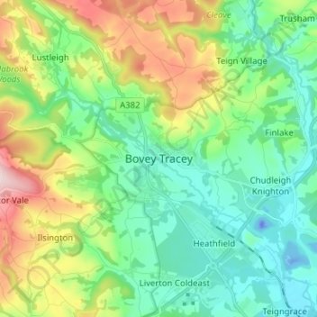
Nome: Mapa topográfico Bovey Tracey, altitude, relevo.
Altitude média: 109 m
Altitude mínima: -37 m
Altitude máxima: 368 m
Obrigado por apoiar este site ❤️
Faça uma doação
Faça uma doação
Outros mapas topográficos
Clique em um mapa para visualizar sua topografia, sua altitude e seu relevo.
Dawlish
United Kingdom > England > Devon > Teignbridge
Little of note happened at Dawlish until the end of the 18th century, when seaside locations on the south coast started to become popular with the wealthy, mainly caused by George III making Weymouth in Dorset his summer holiday residence from 1789. In May 1795, the antiquarian and topographer John Swete spent…
Altitude média: 44 m
Obrigado por apoiar este site ❤️
Faça uma doação
Faça uma doação
Moretonhampstead
United Kingdom > England > Devon > Teignbridge > Moretonhampstead
Altitude média: 237 m