
Mapa topográfico Earnslaw
Clique no mapa para exibir a altitude.
Sobre este mapa
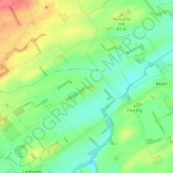
Nome: Mapa topográfico Earnslaw, altitude, relevo.
Local: Earnslaw, Scottish Borders, Scotland, TD12 4JR, United Kingdom (55.69021 -2.33308 55.73021 -2.29308)
Altitude média: 68 m
Altitude mínima: 44 m
Altitude máxima: 108 m
Outros mapas topográficos
Clique em um mapa para visualizar sua topografia, sua altitude e seu relevo.
Greenknowe Tower
United Kingdom > Scotland > Scottish Borders > Gordon > Nether Huntlywood
Altitude média: 157 m
Moffat Hills
United Kingdom > Scotland > Scottish Borders > Tweedsmuir
The Megget Stane (OS. Ref. NT152203) is by a cattle grid at the highest point between the Talla and Megget reservoirs on the minor road which runs from Tweedsmuir on the A701 to Cappercleuch by shore of St Mary's Loch. It is quite easy to miss the stone when coming from Talla as it is hidden by a gate. At an…
Altitude média: 430 m
Curling Pond
United Kingdom > Scotland > Scottish Borders > Earlston > Georgefield
Altitude média: 153 m
Hirsel Lake
United Kingdom > Scotland > Scottish Borders > Coldstream > The Hirsel
Altitude média: 37 m