
Faça uma doação
Mapa topográfico Riley
Clique no mapa para exibir a altitude.
Faça uma doação
Riley
Riley, elevation 807 feet (246 m), is an unincorporated community and census-designated place in McHenry County, Illinois, United States. It was named a CDP before the 2020 census, at which time it had a population of 10.
Faça uma doação
Sobre este mapa
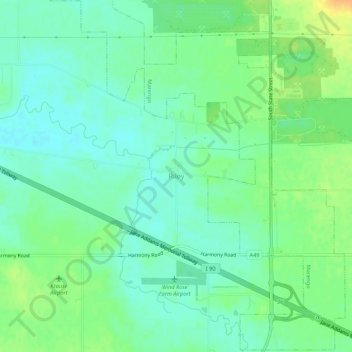
Nome: Mapa topográfico Riley, altitude, relevo.
Local: Riley, McHenry County, Illinois, United States (42.17141 -88.65259 42.21141 -88.61259)
Altitude média: 250 m
Altitude mínima: 239 m
Altitude máxima: 270 m
Faça uma doação
Outros mapas topográficos
Clique em um mapa para visualizar sua topografia, sua altitude e seu relevo.
Faça uma doação
McHenry
United States > Illinois > McHenry County
It rests at an elevation of 797 feet and the Fox River flows through the eastern portion of the city. It is surrounded by natural lakes and streams, grassy moraine hills, gravel banks and shallow nutrient-rich peat bogs, remnants of receding glaciers from the last ice age. Moraine Hills State Park, Glacial…
Altitude média: 237 m
Faça uma doação
Faça uma doação
Faça uma doação
Faça uma doação
Faça uma doação
Faça uma doação