
Mapa topográfico Lakeview
Mapa interativo
Clique no mapa para exibir a altitude.
Sobre este mapa
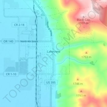
Nome: Mapa topográfico Lakeview, altitude, relevo.
Local: Lakeview, Lake County, Oregon, 97630, United States (42.16423 -120.37558 42.21158 -120.33630)
Altitude média: 1.562 m
Altitude mínima: 1.440 m
Altitude máxima: 1.960 m
Lakeview is a town in Lake County, Oregon, United States. The population was 2,418 at the 2020 census. It is the county seat of Lake County. The city bills itself as the "Tallest Town in Oregon" because of its elevation, 4,802 feet (1,464 m) above sea level. Lakeview is situated in the Goose Lake Valley at the foot of the Warner Mountains and at the edge of Oregon's high desert country. Its economy is based on agriculture, lumber production, and government activities. In addition, tourism is an increasingly important part of the city's economy. Oregon's Outback Scenic Byway passes through Lakeview.
Outros mapas topográficos
Clique em um mapa para visualizar sua topografia, sua altitude e seu relevo.
Fort Rock
United States > Oregon > Lake County
Fort Rock, Lake County, Oregon, United States
Altitude média: 1.326 m
Foster Lake
United States > Oregon > Lake County
Foster Lake, Lake County, Oregon, United States
Altitude média: 1.816 m
Christmas Valley
United States > Oregon > Lake County
Christmas Valley, Lake County, Oregon, 97641, United States
Altitude média: 1.316 m
Adel
United States > Oregon > Lake County
Adel, Lake County, Oregon, 97620, United States
Altitude média: 1.467 m
Green Creek
United States > Oregon > Lake County
Green Creek, Lake County, Oregon, United States
Altitude média: 1.657 m