Mapa topográfico Risaralda
Clique no mapa para exibir a altitude.
Sobre este mapa
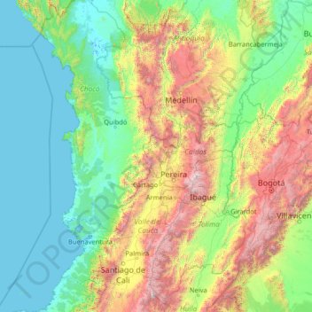
Nome: Mapa topográfico Risaralda, altitude, relevo.
Local: Risaralda, Región Andina, Colombia (2.61029 -78.58422 7.81029 -73.38422)
Altitude média: 861 m
Altitude mínima: -4 m
Altitude máxima: 5.284 m
Outros mapas topográficos
Clique em um mapa para visualizar sua topografia, sua altitude e seu relevo.
Bucaramanga
Colombia > Santander > Bucaramanga
Bucaramanga is located on a plateau in the Cordillera Oriental of the Colombian Andes, and many residents occupy unstable lands descending steeply from the meseta. Westbound of it, the Rio de Oro Canyon is located at an altitude of 600 metres (2,000 ft) above sea level. Eastbound, the Andean Range rises up in…
Altitude média: 1.001 m
Bogota, Capital District
Bogotá is located in the southeastern part of the Bogotá savanna (Sabana de Bogotá) at an average altitude of 2,640 meters (8,660 ft) above sea level. The Bogotá savanna is popularly called "savannah" (sabana), but constitutes actually a high plateau in the Andes mountains, part of an extended region known…
Altitude média: 2.183 m
Medellín
Medellín has 16 comunas (districts), 5 corregimientos (townships), and 271 barrios (neighborhoods). The metropolitan area of Medellín lies within the Aburrá valley at an elevation of 1,500 meters (4,900 feet) above sea level and is bisected by the Medellín River (also called Porce), which flows northward.…
Altitude média: 1.882 m

Providence Island
Colombia > San Andrés and Providencia > Rocky Point
Providencia's maximum elevation is 360 metres (1,180 ft) above sea level. The smaller Santa Catalina Island to the northwest is connected by a 100-metre (330 ft) footbridge to its larger sister Providencia Island. Providencia Island has an area of 17 square kilometres (6.6 sq mi); the two islands cover an area…
Altitude média: 33 m
Chocó
The first city founded by conquistadors in mainland America was Santa María la Antigua del Darién, founded by Vasco Núñez de Balboa in 1510 and disestablished in 1524, just 14 years later. The department was created in 1944. Its low population, mountainous and inhospitable topography, and distance from…
Altitude média: 477 m
Comuna 13 - San Javier
Colombia > Antioquia > Medellín
Comuna 13's geography has played a role in how criminal actors took advantage of the commune as a strategic location, using elevation to better survey the movement of police and rival groups. The elevation additionally played a historical role, as Comuna 13 began as a farming community.
Altitude média: 1.713 m



Filandia
Filandia is the northernmost town of the Department of Quindío. The town is located on the west slope of the Cordillera Central of the Colombian Andes, on the Alto Cauca basin and the Rio La Vieja sub-basin. The main urban area is located at an altitude of 1923 metres above sea level and the altitude range of…
Altitude média: 1.704 m

La Plata
La Plata is a town and municipality in the Huila Department, Colombia, with a municipal population of 61,026 (2018 census) including the rural area, situated at an altitude of 1,050 m. It is located 122 km away from Neiva, 147 km from the city of Popayán and 210 km from the town of San Agustín.
Altitude média: 1.551 m


Santo Domingo
Santo Domingo is a town and municipality in the Colombian department of Antioquia. Part of the subregion of Northeastern Antioquia, it lies at an altitude of 1,975 m (6,480 ft) above sea level.
Altitude média: 1.641 m

Palmira
Palmira is located in southwestern Colombia, lying in the Cauca River valley. 3°31’48” north altitude and 76°81’13” longitude west of Greenwich. The city covers an area of 1,160 km2 (448 sq mi). The city lies at an elevation of 1,000 m (3,300 ft) above sea level.
Altitude média: 1.600 m
Altamira
Altamira is a small pueblo in the department Huila, with a population around 2,416. Its geographical coordinates are 2° 3' 46" North, 75° 47' 14" West. It is about an 8-hour bus trip south of Bogota. The largest city in Huila and its capital is Neiva, which is 89 miles north, with a population of about…
Altitude média: 1.032 m

Calarcá
The municipality has an area of 219.23 km2. Urban area is 2.44 km2. Rural area is 216.79 km2. It varies in altitude between 1000 m above sea level at the confluence of the Quindío y Barragán rivers to 3667 m above sea level in the El Campanario highland area.
Altitude média: 2.149 m


Garagoa
Garagoa (Spanish pronunciation: [ɡaɾaˈɣoa]) is a town and municipality in Colombia, located in the Boyacá Department. It covers an area of 191.75 km2 and the urban centre is located at an altitude of 1,650 metres (5,410 ft) above sea level. Parts of the municipality reach altitudes of 3,050 metres (10,010…
Altitude média: 1.988 m





Perimetro Urbano Pereira
Pereira is located on the central mountain range, on the Otún river valley, and part of the Cauca river valley. Pereira, like many Colombian cities, has high-elevation areas with difficult access or flat or steep parts. The streets are laid out according to the elevation of the respective zones.
Altitude média: 1.486 m
Perímetro Urbano Cúcuta
Colombia > Norte de Santander > Cúcuta
The city is in the eastern part of the Department of North Santander, in the Cordillera Oriental, close to the border with Venezuela. The city's area is 110 square kilometres (42 square miles) and its elevation is 320 metres (1,050 feet) above sea level.
Altitude média: 314 m

Yumbo
Yumbo has a relatively dry but extremely foggy and sunless tropical savanna climate (Köppen Aw) not unlike the climate of Bogotá except substantially hotter due to the lower elevation.
Altitude média: 1.251 m


Abrego
Ábrego (Spanish pronunciation: [ˈaβɾeɣo]) is a Colombian municipality and town located in the department of Norte de Santander. The urban centre is situated at an altitude of 1,398 metres (4,587 ft) in the Eastern Ranges of the Colombian Andes.
Altitude média: 1.557 m
Magdalena
The Department of Magdalena, because of its terrain, and proximity to the sea has an unstable weather. Its Climate is mainly dictated by its global positioning, and because the department of Magdalena is located on the Intertropical Convergence Zone it possess an inter-tropical climate. Temperature in the…
Altitude média: 407 m


Ipiales
Ipiales is a city and Catholic bishopric in Nariño Department, southern Colombia, near the border with Ecuador. It is located at around 0°49′49″N 77°38′40″W / 0.83028°N 77.64444°W / 0.83028; -77.64444, with an elevation of about 2950 m. Ipiales is located on the high plateau called…
Altitude média: 2.902 m






Ráquira
Ráquira, is a municipality and town in Boyacá Department, Colombia, part of the subregion of the Ricaurte Province. Ráquira is situated on the Altiplano Cundiboyacense and the urban center at an altitude of 2,150 metres (7,050 ft). It borders Tinjacá and Sutamarchán in the north, Guachetá, Cundinamarca…
Altitude média: 2.677 m

Fusagasugá ciudad
It was founded in 1592 by Spanish priests. The town located some 56 kilometers from the capital, Bogotá; borders Pasca, Arbeláez, Tibacuy, Silvania and other municipalities of Sumapaz. Its elevation is 5,669 feet (1,728 m) above sea level, and the average temperature 20 °C (68 °F).
Altitude média: 1.802 m

Floridablanca
Floridablanca (Spanish pronunciation: [floˌɾiðaˈβlaŋka], locally also simply Florida) is a municipality in the department of Santander situated at an altitude of 925 metres (3,035 ft) in the Eastern Ranges of the Colombian Andes. It is part of the metropolitan area of the departmental capital…
Altitude média: 1.261 m