
Mapa topográfico Tequixquiac
Mapa interativo
Clique no mapa para exibir a altitude.
Sobre este mapa
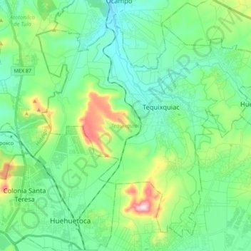
Nome: Mapa topográfico Tequixquiac, altitude, relevo.
Local: Tequixquiac, State of Mexico, Mexico (19.82282 -99.22776 19.96444 -99.05861)
Altitude média: 2.296 m
Altitude mínima: 2.167 m
Altitude máxima: 2.705 m
The municipal seat is located in a small, narrow valley, but most of the municipality is on a high mesa between the Valley of Mexico and the Mezquital Valley. The highest mountain in Tequixquiac is the Cerro Mesa Ahumada, with an elevation of 2,600 metres (8,500 ft) above sea level, on the border between the municipalities of Huehuetoca and Apaxco.