
Mapa topográfico Mount Brandon
Mapa interativo
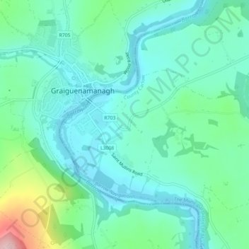
Clique no mapa para exibir a altitude.
Sobre este mapa
Nome: Mapa topográfico Mount Brandon, altitude, relevo.
Altitude média: 56 m
Altitude mínima: 5 m
Altitude máxima: 236 m
Outros mapas topográficos
Clique em um mapa para visualizar sua topografia, sua altitude e seu relevo.
Ballintogher West ED
Ballintogher West ED, Sligo Municipal Borough District, County Sligo, Connacht, Ireland
Altitude média: 75 m
Barr an Ghéaráin
Barr an Ghéaráin, Kenmare Municipal District, County Kerry, Munster, Ireland
Altitude média: 431 m
Battle of the Curlew Mountains
Battle of the Curlew Mountains, L58041, Deerpark, Boyle Rural ED, Boyle Municipal District, County Roscommon, Connacht, F52 KH95, Ireland
Altitude média: 160 m
Rosslee ED
Rosslee ED, Mayo Abbey, County Mayo, Connacht, Ireland
Altitude média: 50 m