
Mapa topográfico Goldach
Mapa interativo
Clique no mapa para exibir a altitude.
Sobre este mapa
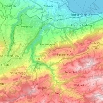
Nome: Mapa topográfico Goldach, altitude, relevo.
Local: Goldach, Mittelland, Appenzell Rhodes-Extérieures, 9037, Suisse (47.39899 9.42844 47.48948 9.50653)
Altitude média: 717 m
Altitude mínima: 392 m
Altitude máxima: 1.121 m
Outros mapas topográficos
Clique em um mapa para visualizar sua topografia, sua altitude e seu relevo.
Gais
Suisse > Appenzell Rhodes-Extérieures > Mittelland
Gais, Mittelland, Appenzell Rhodes-Extérieures, 9056, Suisse
Altitude média: 1.005 m
Trogen
Suisse > Appenzell Rhodes-Extérieures > Mittelland
Trogen, Mittelland, Appenzell Rhodes-Extérieures, 9043, Suisse
Altitude média: 956 m
Teufen (AR)
Suisse > Appenzell Rhodes-Extérieures > Mittelland
Teufen (AR), Mittelland, Appenzell Rhodes-Extérieures, Suisse
Altitude média: 855 m
Stein (AR)
Suisse > Appenzell Rhodes-Extérieures > Hinterland > Stein (AR)
Stein (AR), Hinterland, Appenzell Rhodes-Extérieures, 9063, Suisse
Altitude média: 770 m
Zwislen
Suisse > Appenzell Rhodes-Extérieures > Mittelland > Gais > Zwislen
Zwislen, Gais, Mittelland, Appenzell Rhodes-Extérieures, 9056, Suisse
Altitude média: 986 m
Urnäsch
Suisse > Appenzell Rhodes-Extérieures > Hinterland > Urnäsch > Urnäsch
Urnäsch, Hinterland, Appenzell Rhodes-Extérieures, 9107, Suisse
Altitude média: 959 m
Sitter
Suisse > Appenzell Rhodes-Extérieures > Mittelland
Sitter, Mittelland, Appenzell Rhodes-Extérieures, 8589, Suisse
Altitude média: 763 m
Vorderland
Suisse > Appenzell Rhodes-Extérieures
Vorderland, Appenzell Rhodes-Extérieures, Suisse
Altitude média: 718 m
Hinterland
Suisse > Appenzell Rhodes-Extérieures
Hinterland, Appenzell Rhodes-Extérieures, Suisse
Altitude média: 992 m