
Faça uma doação
Mapa topográfico Georgetown
Clique no mapa para exibir a altitude.
Faça uma doação
Georgetown
Georgetown lies in the central part of Williamson County and features a diverse topography influenced by the Balcones Escarpment. The city itself sits at an average elevation of about 800 feet (244 meters), with its terrain ranging from flatter areas in the east to more hilly and karst-like features in the west. The landscape is shaped by the presence of several creeks and rivers, notably the San Gabriel River, which winds through the city and contributes to local topographical variation. The eastern portions are generally part of the Blackland Prairie, known for its fertile, flat land ideal for agriculture. To the west, the terrain becomes more rugged with steeper slopes and limestone outcrops. This region's combination of lowland prairie and more challenging hill-country terrain contributes to Georgetown's scenic beauty and its appeal for both development and outdoor activities.
Faça uma doação
Sobre este mapa
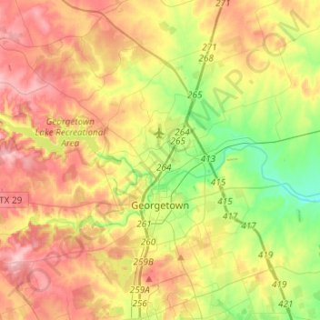
Nome: Mapa topográfico Georgetown, altitude, relevo.
Local: Georgetown, Williamson County, Texas, 78626, United States (30.57080 -97.83279 30.75254 -97.58988)
Altitude média: 247 m
Altitude mínima: 176 m
Altitude máxima: 322 m
Faça uma doação
Outros mapas topográficos
Clique em um mapa para visualizar sua topografia, sua altitude e seu relevo.
Soil Conservation Service Site 12 Dam
United States > Texas > Williamson County > Type
Altitude média: 173 m
Soil Conservation Service Site 12 Dam
United States > Texas > Williamson County > Type
Altitude média: 173 m
Faça uma doação
Soil Conservation Service Site 12 Dam
United States > Texas > Williamson County > Type
Altitude média: 173 m
Georgetown
United States > Texas > Williamson County > Georgetown
The city is located on the northeastern edge of Texas Hill Country. Portions of Georgetown are located on either side of the Balcones Escarpment, a fault line in which the areas roughly east of IH-35 are flat and characterized by having black, fertile soils of the Blackland Prairie, and the west side of the…
Altitude média: 228 m
Faça uma doação
Round Rock
United States > Texas > Williamson County > Round Rock
The city straddles the Balcones Escarpment, a fault line in which the areas roughly east of Interstate 35 are flat and characterized by having black, fertile soils of the Blackland Prairie, and the west side of the Escarpment, which consists mostly of hilly, karst-like terrain with little topsoil and higher…
Altitude média: 236 m