
Mapa topográfico Somersworth
Mapa interativo
Clique no mapa para exibir a altitude.
Sobre este mapa
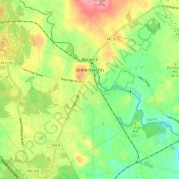
Nome: Mapa topográfico Somersworth, altitude, relevo.
Altitude média: 56 m
Altitude mínima: 8 m
Altitude máxima: 120 m
According to the United States Census Bureau, the city has a total area of 10.0 square miles (25.9 km2), of which 9.8 square miles (25.4 km2) are land and 0.2 square miles (0.5 km2) are water, comprising 1.96% of the city. Somersworth is bordered to the northeast by the Salmon Falls River, which is also the state boundary with Maine. The highest point in Somersworth is Prospect Hill rising just west of the city center, on which the city reservoir is built. The hill's elevation is approximately 310 feet (94 m) above sea level.
Outros mapas topográficos
Clique em um mapa para visualizar sua topografia, sua altitude e seu relevo.
Rollinsford
United States > New Hampshire > Strafford County
Rollinsford, Strafford County, New Hampshire, 03869, United States
Altitude média: 32 m
New Durham
United States > New Hampshire > Strafford County
New Durham, Strafford County, New Hampshire, 03855, United States
Altitude média: 228 m
Dover
United States > New Hampshire > Strafford County
Dover, Strafford County, New Hampshire, 03820, United States
Altitude média: 31 m
Dover
United States > New Hampshire > Strafford County > Dover
Dover, Strafford County, New Hampshire, 03820, United States
Altitude média: 52 m
Lee
United States > New Hampshire > Strafford County
Lee, Strafford County, New Hampshire, 03861, United States
Altitude média: 47 m
Rochester
United States > New Hampshire > Strafford County > Rochester
Rochester, Strafford County, New Hampshire, United States
Altitude média: 90 m