
Mapa topográfico Duncormick
Clique no mapa para exibir a altitude.
Sobre este mapa
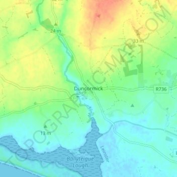
Nome: Mapa topográfico Duncormick, altitude, relevo.
Altitude média: 15 m
Altitude mínima: -2 m
Altitude máxima: 43 m
Outros mapas topográficos
Clique em um mapa para visualizar sua topografia, sua altitude e seu relevo.
Taghmon
Ireland > County Wexford > New Ross Municipal District
Many Irish place names are topographically descriptive, and 'Achadh Liathdrom' is no exception. From the western side of the Forth Mountain, as it slopes down towards Ballintlea, a succession of gradual hills and valleys undulate their way across this part of County Wexford towards Camross, Bree and…
Altitude média: 67 m