
Faça uma doação
Mapa topográfico Upper Arlington
Clique no mapa para exibir a altitude.
Faça uma doação
Upper Arlington
The city is around 800 ft elevation located between the Olentangy and Scioto rivers. Two ravines cut through the city. The Slate Run in the northwest corner flows into the Scioto River. However, the Turkey Run is longer. It originates in the north then runs southwards until it makes an eastward bend around Reed Rd. Then, it flows eastwards through the OSU Golf Course. The run is used as a storm drain at points, has been dammed in the Ohio State course and runs through concrete pipes at two points. The soil is glacial till and is suitable for agriculture, supporting a research farm operated by Ohio State University.
Faça uma doação
Sobre este mapa
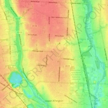
Nome: Mapa topográfico Upper Arlington, altitude, relevo.
Local: Upper Arlington, Franklin County, Ohio, United States (39.98929 -83.10452 40.06548 -83.04254)
Altitude média: 249 m
Altitude mínima: 211 m
Altitude máxima: 279 m
Faça uma doação
Outros mapas topográficos
Clique em um mapa para visualizar sua topografia, sua altitude e seu relevo.
Columbus
United States > Ohio > Franklin County > Columbus
The confluence of the Scioto and Olentangy rivers is just north-west of Downtown Columbus. Several smaller tributaries course through the Columbus metropolitan area, including Alum Creek, Big Walnut Creek, and Darby Creek. Columbus is considered to have relatively flat topography thanks to a large glacier that…
Altitude média: 255 m
Faça uma doação
Faça uma doação