
Faça uma doação
Mapa topográfico Alpine
Clique no mapa para exibir a altitude.
Faça uma doação
Alpine
Alpine (/ˈælpaɪn/ AL-pyne) is a city in and the county seat of Brewster County, Texas, United States. The population was 6,035 at the 2020 census. The town has an elevation of 4,462 feet (1,360 m), and the surrounding mountain peaks are over 1 mile (1.6 km) above sea level. A university, hospital, library, and retail make Alpine the center of the sprawling 12,000 square miles (3,108,000 ha) but wide open Big Bend area (combined population 12,500) including Brewster, Presidio, and Jeff Davis counties.
Faça uma doação
Sobre este mapa
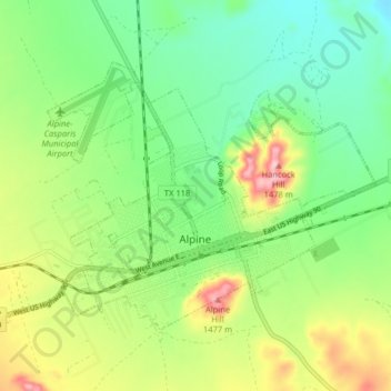
Nome: Mapa topográfico Alpine, altitude, relevo.
Local: Alpine, Brewster County, Texas, United States (30.34404 -103.70590 30.39172 -103.62556)
Altitude média: 1.373 m
Altitude mínima: 1.305 m
Altitude máxima: 1.493 m
Faça uma doação
Outros mapas topográficos
Clique em um mapa para visualizar sua topografia, sua altitude e seu relevo.
Emory Peak
United States > Texas > Brewster County
The peak can be reached by a moderate hike on a well-marked path across steep rocky terrain with an elevation gain of approximately 2,500 feet (760 m). The Emory Peak Trail is about 1.5 miles (2.4 km) long. The trail is reached by climbing the Pinnacles Trail 3.5 miles (5.6 km) from the Chisos Basin trailhead.…
Altitude média: 2.061 m
Faça uma doação