
Faça uma doação
Mapa topográfico Boston
Clique no mapa para exibir a altitude.
Faça uma doação
Sobre este mapa
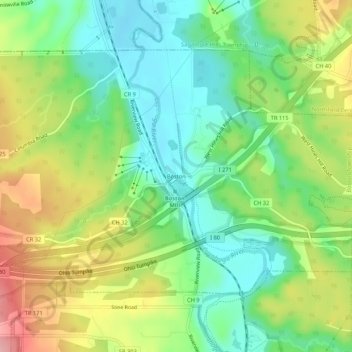
Nome: Mapa topográfico Boston, altitude, relevo.
Altitude média: 245 m
Altitude mínima: 191 m
Altitude máxima: 329 m
Faça uma doação
Outros mapas topográficos
Clique em um mapa para visualizar sua topografia, sua altitude e seu relevo.
Akron
United States > Ohio > Summit County
Akron is situated within the Glaciated Allegheny Plateau, creating a rolling landscape with variable elevations. The city, which lies around 40 miles south of Lake Erie, has an average elevation of approximately 960 feet above sea level, though elevations range from about 700 feet along the Cuyahoga River…
Altitude média: 315 m
Faça uma doação
Cuyahoga Valley National Park
United States > Ohio > Summit County > Cuyahoga Heights
Altitude média: 313 m
Faça uma doação
Faça uma doação
Faça uma doação
Faça uma doação
Faça uma doação
Cuyahoga Valley National Park
United States > Ohio > Summit County > Cuyahoga Heights
Altitude média: 313 m
Faça uma doação
Akron
United States > Ohio > Summit County
Akron is located in the Great Lakes region about 39 miles (63 km) south of Lake Erie, on the Glaciated Allegheny Plateau. It is bordered by Cuyahoga Falls on the north and Barberton in the southwest. It is the center of the Akron metropolitan area which covers Summit and Portage Counties, and a principal city…
Altitude média: 315 m
Faça uma doação
Faça uma doação
Faça uma doação