
Faça uma doação
Mapa topográfico Belton
Clique no mapa para exibir a altitude.
Faça uma doação
Belton
Belton is located 60 miles (97 km) north of Austin, 137 miles (220 km) south of Dallas, and 184 miles (296 km) west of Houston. It is near the center of Bell County at the point where the Blackland Prairie, characterized by level ground and deep fertile soil, and the Edwards Plateau, characterized by its many springs, hills, and steep canyons, meet. Its elevation is approximately 509 feet (155 m).
Faça uma doação
Sobre este mapa
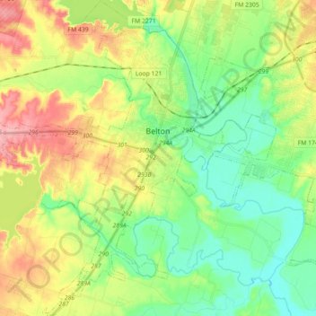
Nome: Mapa topográfico Belton, altitude, relevo.
Local: Belton, Bell County, Texas, United States (30.96710 -97.55972 31.11892 -97.42600)
Altitude média: 179 m
Altitude mínima: 133 m
Altitude máxima: 255 m
Faça uma doação
Outros mapas topográficos
Clique em um mapa para visualizar sua topografia, sua altitude e seu relevo.
Belton
United States > Texas > Bell County > Belton > Belton
Belton is located 60 miles (97 km) north of Austin, 137 miles (220 km) south of Dallas, and 184 miles (296 km) west of Houston. It is near the center of Bell County at 31°3′32″N 97°27′48″W / 31.05889°N 97.46333°W / 31.05889; -97.46333 (31.058904, -97.463382). It is at the point where the…
Altitude média: 176 m
Faça uma doação
Belton
United States > Texas > Bell County
Belton is located 60 miles (97 km) north of Austin, 137 miles (220 km) south of Dallas, and 184 miles (296 km) west of Houston. It is near the center of Bell County at 31°3′32″N 97°27′48″W / 31.05889°N 97.46333°W / 31.05889; -97.46333 (31.058904, –97.463382). Belton is at the point where…
Altitude média: 179 m
Faça uma doação