
Mapa topográfico Mapleton Falls
Clique no mapa para exibir a altitude.
Sobre este mapa
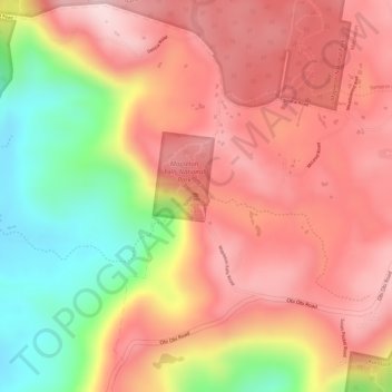
Nome: Mapa topográfico Mapleton Falls, altitude, relevo.
Altitude média: 330 m
Altitude mínima: 144 m
Altitude máxima: 440 m
Outros mapas topográficos
Clique em um mapa para visualizar sua topografia, sua altitude e seu relevo.
Minyama
Australia > Queensland > Sunshine Coast Regional
Minyama is located within the Kawana Waters urban centre. Situated on the Mooloolah River, the suburb is almost entirely surrounded by water, and artificially constructed harbours and waterways dominate the topography. The suburb's main thoroughfare, Nicklin Way, is the location of several large retail…
Altitude média: 3 m