
Faça uma doação
Mapa topográfico Gilan Province
Clique no mapa para exibir a altitude.
Faça uma doação
Sobre este mapa
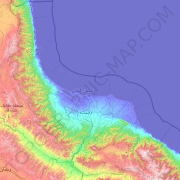
Nome: Mapa topográfico Gilan Province, altitude, relevo.
Local: Gilan Province, Iran (36.55040 48.53618 38.46034 50.73154)
Altitude média: 591 m
Altitude mínima: -31 m
Altitude máxima: 3.756 m
Faça uma doação
Outros mapas topográficos
Clique em um mapa para visualizar sua topografia, sua altitude e seu relevo.
Zagros Mountains
Iran > Isfahan Province > Semirom County > Padena-ye Vosta RD
Altitude média: 3.846 m
Zagros Mountains
Iran > Isfahan Province > Semirom County > Padena-ye Vosta RD
Altitude média: 3.846 m
Faça uma doação
جاده میانکاله
Iran > Golestan Province > Torkaman County > South Chaparbay District > آشوراده
Altitude média: -27 m
Faça uma doação
Faça uma doação
Faça uma doação
Faça uma doação
Damavand
Iran > Mazandaran Province > Amol County > دهستان لاریجان سفلی
Mount Damavand (Persian: دماوند [dæmɒːˈvænd] English: /dɔːmoʊˈvænd/ Da-moh-VAND) is a dormant stratovolcano in Iran. It is the highest peak in Iran and Western Asia, the highest volcano in Asia, and the 3rd highest volcano in the Eastern Hemisphere (after Mount Kilimanjaro and Mount Elbrus), at…
Altitude média: 4.949 m
Iranian plateau
Iran > South Khorasan Province > Tabas County > دهستان دیهوک
The northwestern Iranian plateau, where the Pontic and Taurus Mountains converge, is rugged country with higher elevations, a more severe climate, and greater precipitation than are found on the Anatolian plateau. The region is known as the Anti-Taurus, and the average elevation of its peaks exceeds 3,000 m…
Altitude média: 1.061 m
Faça uma doação
Damavand
Iran > Mazandaran Province > Amol County > دهستان لاریجان سفلی
Mount Damavand (Persian: دماوند [dæmɒːvænd] ) is a dormant stratovolcano and is the highest peak in Iran and Western Asia, the highest volcano in Asia, and the 3rd highest volcano in the Eastern Hemisphere (after Mount Kilimanjaro and Mount Elbrus), at an elevation of 5,609 metres (18,402 ft).…
Altitude média: 4.949 m
Faça uma doação
Faça uma doação
Alborz Mountains
Iran > Mazandaran Province > Amol County > دهستان لاریجان سفلی
While the southern slopes of the Alborz Mountains are usually semiarid or arid, with irregular and low precipitation, the northern slopes of the range are usually humid, especially in the western parts of the Central Alborz. The Alborz is the easternmost extent of many European plant species. In the southern…
Altitude média: 4.934 m
Faça uma doação
Band-e Amir
Iran > Fars Province > Zarghan County > Band-e Amir Rural District
Altitude média: 1.598 m
Faça uma doação
Soltanabad-e Tanbali
Iran > Kurdistan Province > Bijar County > دهستان نجف آباد
Altitude média: 2.027 m
Faça uma doação
Faça uma doação
Faça uma doação
Taftan
Iran > Sistan and Baluchestan Province > Mirjaveh County > دهستان تمین
Taftan is the highest mountain in southeast Iran. The topography is overall steep. Deep valleys with U and V shapes have developed on Taftan, and the volcano has a strongly eroded appearance. One of these valleys, Tamindan, may be the Damindan valley in the Avesta religious texts. One series of ignimbrites…
Altitude média: 3.525 m
Faça uma doação
Faça uma doação
Khalifan, Mahabad
Iran > West Azerbaijan Province > Mahabad County > دهستان کانی بازار
Altitude média: 1.558 m
Suran
Iran > Sistan and Baluchestan Province > Sib and Suran County > دهستان سیب وسوران
Altitude média: 1.157 m
Pardisan Park
Iran > Sistan and Baluchestan Province > Zahedan County > Zahedan
Altitude média: 1.400 m
Faça uma doação
Faça uma doação
Amlash
Iran > Gilan Province > Amlash County > دهستان املش شمالی
Amlash (Persian: املش) is a city in the Central District of Amlash County, Gilan province, in northwestern Iran, serving as the capital of both the county and the district. Amlash sits at an altitude of 13 metres (45 feet).
Altitude média: 66 m
Faça uma doação
Faça uma doação
Mozdooran Cave
Iran > Razavi Khorasan > Sarakhs County > دهستان مرزداران > Mazdavand
Altitude média: 976 m
Faça uma doação
Nehbandan
Iran > South Khorasan Province > Nehbandan County > دهستان نه
Nehbandan is located at an altitude of 1196 meters above sea level, and the heights of the north of this city reach 2500 meters above sea level. Nehbandan is located near the central desert of Iran. Precious stones in mines along with agriculture is another reason for the importance of Nehbandan. The people of…
Altitude média: 1.209 m
سیوه کده سفلی
Iran > West Azerbaijan Province > Piranshahr County > دهستان لاهیجان شرقی
Altitude média: 1.978 m
Faça uma doação
Faça uma doação
Faça uma doação
عزیزآباد پایین
Iran > Sistan and Baluchestan Province > Konarak County > دهستان تنگ
Altitude média: 9 m
Faça uma doação
Faça uma doação