
Obrigado por apoiar este site ❤️
Faça uma doação
Faça uma doação
Mapa topográfico Tembagapura
Clique no mapa para exibir a altitude.
Obrigado por apoiar este site ❤️
Faça uma doação
Faça uma doação
Tembagapura
Tembagapura is situated on a rocky plain at an altitude of 1,930 metres (6,330 ft) at the base of Mount Zaagkam, which lies 16 kilometres (9.9 mi) southeast of the mine. The town is in the Sudirman Range, not far from Puncak Jaya (Mount Carstens), the highest peak in Oceania. The area gets about 3,220 millimetres (127 in) of rainfall each year. The weather is usually sunny in the morning, changing to cloudy and cool around noon.
Obrigado por apoiar este site ❤️
Faça uma doação
Faça uma doação
Sobre este mapa
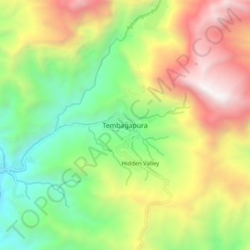
Nome: Mapa topográfico Tembagapura, altitude, relevo.
Altitude média: 2.488 m
Altitude mínima: 1.344 m
Altitude máxima: 4.062 m
Obrigado por apoiar este site ❤️
Faça uma doação
Faça uma doação
Outros mapas topográficos
Clique em um mapa para visualizar sua topografia, sua altitude e seu relevo.