
Faça uma doação
Mapa topográfico Stonecrest
Clique no mapa para exibir a altitude.
Faça uma doação
Sobre este mapa
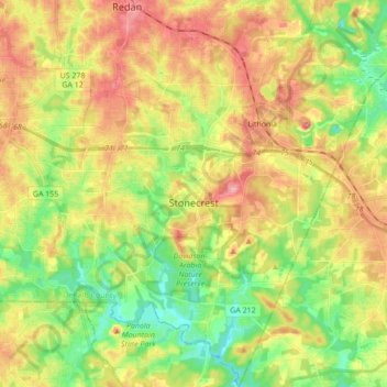
Nome: Mapa topográfico Stonecrest, altitude, relevo.
Local: Stonecrest, DeKalb County, Georgia, 30038, United States (33.61467 -84.20175 33.75808 -84.07433)
Altitude média: 258 m
Altitude mínima: 201 m
Altitude máxima: 324 m
Faça uma doação
Outros mapas topográficos
Clique em um mapa para visualizar sua topografia, sua altitude e seu relevo.
Stone Mountain
United States > Georgia > DeKalb County
The park is owned by the state of Georgia and is currently managed by Herschend Family Entertainment. At its summit, the elevation is 1,686 feet (514 m) above sea level and 825 feet (251 m) above the surrounding area. Stone Mountain is well known for not only its geology, but also the enormous rock relief on…
Altitude média: 299 m
Faça uma doação
Stone Mountain
United States > Georgia > DeKalb County
The park is owned by the state of Georgia. At its summit, the elevation is 1,686 feet (514 m) above sea level and 825 feet (251 m) above the surrounding area. Stone Mountain is well known for not only its geology, but also the enormous rock relief on its north face, the largest bas-relief artwork in the world.…
Altitude média: 299 m
Faça uma doação