
Faça uma doação
Mapa topográfico Milton
Clique no mapa para exibir a altitude.
Faça uma doação
Milton
According to the U.S. Census Bureau, the city of Milton has a total area of 39.2 square miles (101.4 km2), of which 38.5 square miles (99.8 km2) is land and 0.62 square miles (1.6 km2), or 1.59%, is water. The elevation ranges from 950 to 1,280 feet (290 to 390 m) above sea level.
Faça uma doação
Sobre este mapa
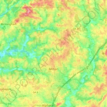
Nome: Mapa topográfico Milton, altitude, relevo.
Local: Milton, Fulton County, Georgia, 30004, United States (34.07717 -84.39658 34.18629 -84.24473)
Altitude média: 330 m
Altitude mínima: 284 m
Altitude máxima: 392 m
Faça uma doação
Outros mapas topográficos
Clique em um mapa para visualizar sua topografia, sua altitude e seu relevo.
Atlanta
United States > Georgia > Fulton County
Atlanta (/ætˈlæntə/ at-LAN-tə) is the capital and most populous city of the U.S. state of Georgia. It is the seat of Fulton County, the most populous county in Georgia. With a population of 498,715 living within the city limits, it is the eighth most populous city in the Southeast and 38th most populous…
Altitude média: 285 m
Faça uma doação
Capital City Country Club Lake Dam
United States > Georgia > Fulton County > Atlanta
Altitude média: 294 m
Faça uma doação
Faça uma doação
Johns Creek
United States > Georgia > Fulton County > Johns Creek
Johns Creek is located in northeastern Fulton County and is centered at 34°1′44″N 84°11′55″W / 34.02889°N 84.19861°W / 34.02889; -84.19861 (34.0289259, -84.1985790). The elevation ranges from 880 feet (270 m) above sea level along the Chattahoochee River to 1,180 feet (360 m) in the Ocee…
Altitude média: 314 m
Faça uma doação