
Mapa topográfico Yongfu County
Mapa interativo
Clique no mapa para exibir a altitude.
Sobre este mapa
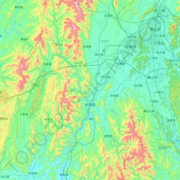
Nome: Mapa topográfico Yongfu County, altitude, relevo.
Local: Yongfu County, Guilin, Guangxi, China (24.64826 109.61164 25.44246 110.23691)
Altitude média: 344 m
Altitude mínima: 101 m
Altitude máxima: 1.361 m
Yongfu County (Chinese: 永福县; pinyin: Yǒngfú Xiàn) is a county under the administration of the prefecture-level city of Guilin, Guangxi, China, located 55 km (34 mi) to the southwest of downtown Guilin. The county is mostly rural and hilly, marked by the same dramatic karst topography for which Guilin is famous.