
Faça uma doação
Mapa topográfico Hinterstoder
Clique no mapa para exibir a altitude.
Faça uma doação
Hinterstoder
Hinterstoder is a municipality in the district of Kirchdorf an der Krems, in the Austrian state of Upper Austria. The village lies on the southern edge of the district near the border with Styria, at an altitude of around 600 m. Surrounded by the limestone peaks of the Totes Gebirge range, including the Großer Priel (2,514 m) and the Spitzmauer (2,446 m), Hinterstoder has developed from a small alpine settlement into an internationally recognized ski resort.
Faça uma doação
Sobre este mapa
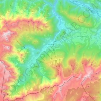
Nome: Mapa topográfico Hinterstoder, altitude, relevo.
Local: Hinterstoder, Bezirk Kirchdorf, Upper Austria, 4573, Austria (47.61590 14.01060 47.76613 14.21258)
Altitude média: 1.283 m
Altitude mínima: 485 m
Altitude máxima: 2.501 m
Faça uma doação
Outros mapas topográficos
Clique em um mapa para visualizar sua topografia, sua altitude e seu relevo.