
Faça uma doação
Mapa topográfico Babuyan Island
Clique no mapa para exibir a altitude.
Faça uma doação
Sobre este mapa
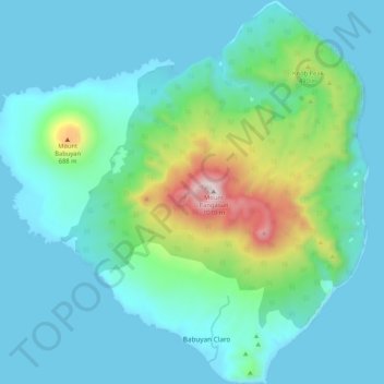
Nome: Mapa topográfico Babuyan Island, altitude, relevo.
Altitude média: 185 m
Altitude mínima: 0 m
Altitude máxima: 1.061 m
Faça uma doação
Outros mapas topográficos
Clique em um mapa para visualizar sua topografia, sua altitude e seu relevo.
Mount Pangasun
Philippines > Cagayan > Calayan
Babuyan Claro is a stratovolcano with an elevation of 843 meters (2,766 ft) and a base diameter of about 8 kilometers (5.0 mi) located in the center of Babuyan Island (also referred to as Babuyan Claro Island). It has four morphologically-fresh volcanic edifices: Mt. Cayonan in the south, Mt. Naydi and Mt.…
Altitude média: 688 m
Didicas Volcano
Philippines > Cagayan > Calayan
Didicas is topped with a lava dome with an elevation of 228 metres (748 ft) and a base diameter of 1,200 metres (3,900 ft) at sea level. It is at the southern end of the Luzon Volcanic Arc, and like all the volcanoes in the Philippines, is part of the Pacific ring of fire.
Altitude média: 7 m
Faça uma doação
Faça uma doação