
Obrigado por apoiar este site ❤️
Faça uma doação
Faça uma doação
Mapa topográfico Bagalkote
Clique no mapa para exibir a altitude.
Obrigado por apoiar este site ❤️
Faça uma doação
Faça uma doação
Bagalkote
Bagalkote, is a city in the state of Karnataka, India, which is also the headquarters of Bagalkot district. It is situated on branch of River Ghataprabha, The population of the urban agglomeration was 111,933 according to the provisional results of 2011 national census of India, the city is spread over an area of 49.06 square kilometres (18.94 sq mi) with an average elevation of 532 m (1,745 ft) above MSL.
Obrigado por apoiar este site ❤️
Faça uma doação
Faça uma doação
Sobre este mapa
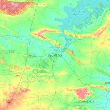
Nome: Mapa topográfico Bagalkote, altitude, relevo.
Altitude média: 556 m
Altitude mínima: 504 m
Altitude máxima: 696 m
Obrigado por apoiar este site ❤️
Faça uma doação
Faça uma doação