
Mapa topográfico Black Butte
Mapa interativo
Clique no mapa para exibir a altitude.
Sobre este mapa
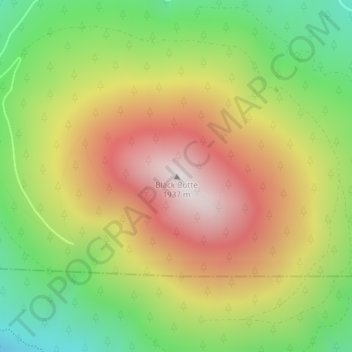
Nome: Mapa topográfico Black Butte, altitude, relevo.
Local: Black Butte, Jefferson County, Oregon, United States (44.40003 -121.63651 44.40013 -121.63641)
Altitude média: 1.514 m
Altitude mínima: 1.102 m
Altitude máxima: 1.952 m
According to the U.S. National Geodetic Survey and scientists from the United States Geological Survey, Black Butte has an elevation of 6,436 feet (1,962 m); the Geographic Names Information System database lists its elevation as 6,430 feet (1,960 m), while Oregon Geographic Names lists its elevation at 6,415 feet (1,955 m). The butte has proximal and draping reliefs of 2,490 feet (760 m) and 3,150 feet (960 m), which are the "difference between summit elevation and that of highest exposure of older rocks overlain by the edifice" and the "difference between summit elevation and that of lowest distal lavas of the edifice (not including distal pyroclastic or debris flows)," respectively. According to E. M. Taylor, Black Butte has a diameter of 4 miles (6.4 km).
Outros mapas topográficos
Clique em um mapa para visualizar sua topografia, sua altitude e seu relevo.
Culver
United States > Oregon > Jefferson County
Culver, Jefferson County, Oregon, United States
Altitude média: 807 m
Lake Billy Chinook
United States > Oregon > Jefferson County
Lake Billy Chinook, Jefferson County, Oregon, United States
Altitude média: 776 m
Madras
United States > Oregon > Jefferson County
Madras, Jefferson County, Oregon, United States
Altitude média: 739 m
Camp Sherman
United States > Oregon > Jefferson County
Camp Sherman, Jefferson County, Oregon, 97730, United States
Altitude média: 939 m
Crooked River Ranch
United States > Oregon > Jefferson County
Crooked River Ranch, Jefferson County, Oregon, United States
Altitude média: 825 m
Peter Skene Ogden State Scenic Viewport
United States > Oregon > Jefferson County
Peter Skene Ogden State Scenic Viewport, Jefferson County, Oregon, United States
Altitude média: 839 m
Warm Springs
United States > Oregon > Jefferson County > Warm Springs
Warm Springs, Jefferson County, Oregon, 97761, United States
Altitude média: 650 m
Mount Jefferson
United States > Oregon > Jefferson County
Mount Jefferson, Jefferson County, Oregon, United States
Altitude média: 2.537 m