
Obrigado por apoiar este site ❤️
Faça uma doação
Faça uma doação
Mapa topográfico Balut Island
Clique no mapa para exibir a altitude.
Obrigado por apoiar este site ❤️
Faça uma doação
Faça uma doação
Balut Island
Balut Island, the westernmost of the Sarangani Islands, is the larger, higher, and better cultivated than Sarangani Island. In the center of the island is Balut Volcano, which is fumarolic on occasion. Balut Island rises to about 1,800 metres (5,900 ft) from the seabed with the highest elevation at 862 metres (2,828 ft) above mean sea level. Base diameter of the island is 8 kilometres (5.0 mi).
Obrigado por apoiar este site ❤️
Faça uma doação
Faça uma doação
Sobre este mapa
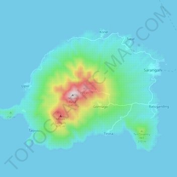
Nome: Mapa topográfico Balut Island, altitude, relevo.
Altitude média: 87 m
Altitude mínima: 0 m
Altitude máxima: 827 m
Obrigado por apoiar este site ❤️
Faça uma doação
Faça uma doação
Outros mapas topográficos
Clique em um mapa para visualizar sua topografia, sua altitude e seu relevo.