
Mapa topográfico Santa Barbara
Mapa interativo
Clique no mapa para exibir a altitude.
Sobre este mapa
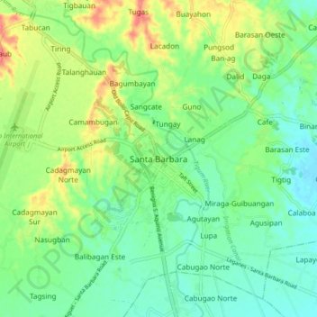
Nome: Mapa topográfico Santa Barbara, altitude, relevo.
Local: Santa Barbara, Iloilo, Western Visayas, 5002, Philippines (10.78723 122.49147 10.86723 122.57147)
Altitude média: 34 m
Altitude mínima: 10 m
Altitude máxima: 79 m
The topography of Santa Barbara varies from slightly rolling hills to almost flat or gradually inclined plains, sliced by Tigum River at its centremost, which flows from the north-west to the southeast and the Aganan River in the southern section.