
Obrigado por apoiar este site ❤️
Faça uma doação
Faça uma doação
Mapa topográfico Armenia
Clique no mapa para exibir a altitude.
Obrigado por apoiar este site ❤️
Faça uma doação
Faça uma doação
Armenia
Armenia has a territorial area of 29,743 square kilometres (11,484 sq mi). The terrain is mostly mountainous, with fast flowing rivers, and few forests. The land rises to 4,090 metres (13,419 feet) above sea level at Mount Aragats, and no point is below 390 metres (1,280 ft) above sea level. Average elevation of the country area is 10th highest in the world and it has 85.9% mountain area, more than Switzerland or Nepal.
Obrigado por apoiar este site ❤️
Faça uma doação
Faça uma doação
Sobre este mapa
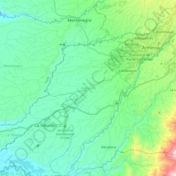
Nome: Mapa topográfico Armenia, altitude, relevo.
Local: Armenia, Capital, Quindío, Colombia (4.39574 -75.78940 4.58959 -75.63250)
Altitude média: 1.709 m
Altitude mínima: 1.078 m
Altitude máxima: 3.715 m
Obrigado por apoiar este site ❤️
Faça uma doação
Faça uma doação