
Mapa topográfico Wullendorf
Mapa interativo
Clique no mapa para exibir a altitude.
Sobre este mapa
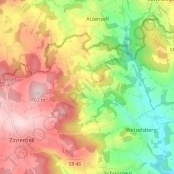
Nome: Mapa topográfico Wullendorf, altitude, relevo.
Altitude média: 548 m
Altitude mínima: 389 m
Altitude máxima: 700 m
Outros mapas topográficos
Clique em um mapa para visualizar sua topografia, sua altitude e seu relevo.
Hub
Deutschland > Bayern > Landkreis Straubing-Bogen > Wiesenfelden
Hub, Wiesenfelden, Landkreis Straubing-Bogen, Bayern, Deutschland
Altitude média: 578 m
Hohenried
Deutschland > Bayern > Landkreis Straubing-Bogen > Wiesenfelden
Hohenried, Wiesenfelden, Landkreis Straubing-Bogen, Bayern, 94350, Deutschland
Altitude média: 634 m