
Faça uma doação
Mapa topográfico Virginia Beach
Clique no mapa para exibir a altitude.
Faça uma doação
Virginia Beach
According to the United States Census Bureau, the city has a total area of 497 square miles (1,290 km2), of which 249 square miles (640 km2) is land and 248 square miles (640 km2) (49.9%) is water. It is the largest city in Virginia by total area and third-largest city land area. The average elevation is 12 feet (3.7 m) above sea level. A major portion of the city drains to the Chesapeake Bay by way of the Lynnhaven River and its tributaries.
Faça uma doação
Sobre este mapa
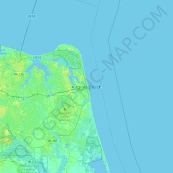
Nome: Mapa topográfico Virginia Beach, altitude, relevo.
Local: Virginia Beach, Virginia, 23451, United States (36.69298 -76.13742 37.01298 -75.81742)
Altitude média: 2 m
Altitude mínima: -12 m
Altitude máxima: 17 m
Faça uma doação
Outros mapas topográficos
Clique em um mapa para visualizar sua topografia, sua altitude e seu relevo.