
Obrigado por apoiar este site ❤️
Faça uma doação
Faça uma doação
Mapa topográfico Heathfield
Clique no mapa para exibir a altitude.
Obrigado por apoiar este site ❤️
Faça uma doação
Faça uma doação
Sobre este mapa
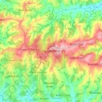
Nome: Mapa topográfico Heathfield, altitude, relevo.
Altitude média: 99 m
Altitude mínima: 36 m
Altitude máxima: 184 m
Obrigado por apoiar este site ❤️
Faça uma doação
Faça uma doação
Outros mapas topográficos
Clique em um mapa para visualizar sua topografia, sua altitude e seu relevo.
Crowborough
United Kingdom > England > East Sussex > Wealden
In the late 19th century, Crowborough was promoted as a health resort based on its high elevation, the rolling hills and surrounding forest. Estate Agents even called it "Scotland in Sussex". The town's golf course opened in 1895, followed by a fire station and hospital in 1900.
Altitude média: 146 m
Obrigado por apoiar este site ❤️
Faça uma doação
Faça uma doação