
Obrigado por apoiar este site ❤️
Faça uma doação
Faça uma doação
Mapa topográfico Pratapgarh
Clique no mapa para exibir a altitude.
Obrigado por apoiar este site ❤️
Faça uma doação
Faça uma doação
Pratapgarh
Pratapgarh District is a newly constituted district in Rajasthan state. it came into existence on 26 January 2008, as the 33rd district of Rajasthan. Pratapgarh is located at 24.03° N 74.78° E. It has an average elevation of 491 metres (1610 feet). It is said to be the second highest place in Rajasthan after Mount Abu.
Obrigado por apoiar este site ❤️
Faça uma doação
Faça uma doação
Sobre este mapa
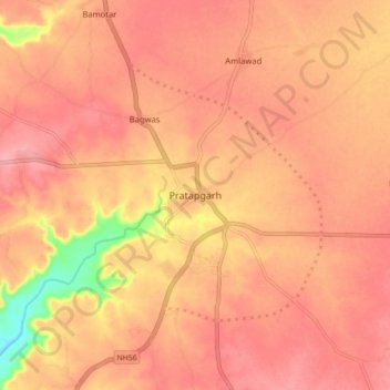
Nome: Mapa topográfico Pratapgarh, altitude, relevo.
Altitude média: 503 m
Altitude mínima: 428 m
Altitude máxima: 529 m
Obrigado por apoiar este site ❤️
Faça uma doação
Faça uma doação