
Faça uma doação
Mapa topográfico James Island
Clique no mapa para exibir a altitude.
Faça uma doação
James Island
James Island, one of British Columbia's Gulf Islands, lies in Haro Strait between Sidney Island and the coast of Vancouver Island near Sidney, British Columbia. James Island is approximately 2.4 km (1.5 mi) from the coast of Vancouver Island, and 145 km (90 mi) from Seattle, Washington. James Island has an elevation of 145 metres (476 feet) above sea level at its highest point, and has a total land-mass of 315 hectares (780 acres). There are sea-cliffs on the Southern, Western, and Eastern shores of this island. The Southern sea-cliffs are the highest.
Faça uma doação
Sobre este mapa
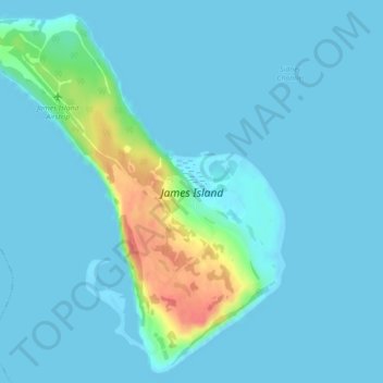
Nome: Mapa topográfico James Island, altitude, relevo.
Altitude média: 8 m
Altitude mínima: -1 m
Altitude máxima: 63 m
Faça uma doação
Outros mapas topográficos
Clique em um mapa para visualizar sua topografia, sua altitude e seu relevo.
Mayne
Canada > British Columbia > Capital Regional District > Southern Gulf Islands Electoral Area
Altitude média: 52 m
Mount Parke
Canada > British Columbia > Capital Regional District > Southern Gulf Islands Electoral Area
Altitude média: 74 m
Galiano
Canada > British Columbia > Capital Regional District > Southern Gulf Islands Electoral Area
Altitude média: 82 m
Mayne
Canada > British Columbia > Capital Regional District > Southern Gulf Islands Electoral Area
Altitude média: 52 m
Faça uma doação
Mayne
Canada > British Columbia > Capital Regional District > Southern Gulf Islands Electoral Area
Altitude média: 52 m