
Faça uma doação
Mapa topográfico Westwood
Clique no mapa para exibir a altitude.
Faça uma doação
Sobre este mapa
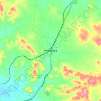
Nome: Mapa topográfico Westwood, altitude, relevo.
Local: Westwood, Rockhampton Regional, Queensland, Australia (-23.66253 150.11557 -23.58253 150.19557)
Altitude média: 190 m
Altitude mínima: 108 m
Altitude máxima: 342 m
Faça uma doação
Outros mapas topográficos
Clique em um mapa para visualizar sua topografia, sua altitude e seu relevo.
City of Brisbane
Brisbane's topography is characterized by a series of hills and ranges that define its landscape. The city is situated on a low-lying floodplain, with the Brisbane River meandering through its heart, creating a winding course with many steep curves from the southwest to its mouth at Moreton Bay in the east.…
Altitude média: 71 m
Faça uma doação
Herbert River
With its headwaters forming at an elevation of 1,070 metres (3,510 ft) on the Atherton Tableland, part of the Great Dividing Range west of Herberton and north of Ravenshoe, the Herbert River is formed by the confluence of the Millstream and the Wild River. The Herbert River flows in a generally southeastern…
Altitude média: 458 m
Faça uma doação
Faça uma doação
Faça uma doação
Faça uma doação
Faça uma doação
Sunshine Coast Regional
The Sunshine Coast Regional area in Queensland, Australia, features a diverse topography that ranges from coastal plains to rugged hinterlands. Along the coastline, the terrain is predominantly flat, with average elevations around 20 meters (66 feet) above sea level. Inland, the landscape transitions to…
Altitude média: 56 m
Faça uma doação
Warwick
Warwick experiences an altitude-influenced humid subtropical climate (Köppen: Cfa), with hot summers and mild, relatively dry winters with cold nights. Annual precipitation averages 662.4 millimetres (26.08 in), with a summer maximum. The town is slightly cooler and less humid than the proximate southeast…
Altitude média: 474 m
Faça uma doação
Faça uma doação
Faça uma doação
Alexandra Hills
Scribbly Gums Conservation Area is located on the eastern edge of Alexandra Hills, bordered by Redland Hospital to the east, and Flinders St and Winchester Rd to the north. The conservation area occupies approximately 152 hectares and contains the Redlands Track Park - a collection of 30+ mountain bike trails…
Altitude média: 34 m
Faça uma doação
Faça uma doação
Faça uma doação
Faça uma doação
Faça uma doação
Bribie Island
Australia > Queensland > Brisbane
Bribie Island, located in Queensland, Australia, is a low-lying, elongated landmass stretching approximately 34 kilometers (21 miles) in length and up to 8 kilometers (5 miles) at its widest point. Composed predominantly of coastal sand plains, the island features two large, low-lying dunes extending…
Altitude média: 6 m
Faça uma doação
Faça uma doação
Faça uma doação
Brisbane River
Riverfire, which began in 1998, was a festival held in September each year at South Bank Parklands and surrounding areas (including the Victoria Bridge), to celebrate the Brisbane River. In 2009, the festival merged with Brisbane Festival. Riverfire, which was held at the end of the Brisbane Festival until…
Altitude média: 44 m
Faça uma doação
Faça uma doação
Faça uma doação
Faça uma doação
Faça uma doação
Faça uma doação