
Mapa topográfico Fairlie
Mapa interativo
Clique no mapa para exibir a altitude.
Sobre este mapa
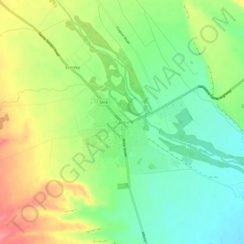
Nome: Mapa topográfico Fairlie, altitude, relevo.
Local: Fairlie, Mackenzie District, Canterbury, 7925, New Zealand (-44.11758 170.80894 -44.07758 170.84894)
Altitude média: 317 m
Altitude mínima: 279 m
Altitude máxima: 371 m
Fairlie is a Mackenzie District service town (or township) located in the Canterbury region of the South Island of New Zealand. The estimated population was 930 as of June 2022. Being on state highway 8 between Christchurch (182 km, 2 hours 20 minutes drive) and Queenstown (300 km 3.5 hours drive), tourism is fast becoming a major industry within the town. Kimbell is 8 km west of Fairlie via state highway 8. Geraldine is 45 km east via state highway 79 and Timaru is 58 km southeast of Fairlie via state highway 8. Fairlie sits at an altitude of 301 metres above sea level.
Outros mapas topográficos
Clique em um mapa para visualizar sua topografia, sua altitude e seu relevo.
Lake Tekapo
New Zealand > Canterbury > Mackenzie District
Lake Tekapo, Mackenzie District, Canterbury, New Zealand
Altitude média: 1.025 m
Mount Annan
New Zealand > Canterbury > Mackenzie District
Mount Annan, Mackenzie District, Canterbury, New Zealand
Altitude média: 2.376 m
Mount Cook
New Zealand > Canterbury > Mackenzie District
Mount Cook, Mackenzie District, Canterbury, New Zealand
Altitude média: 2.920 m
One Metre Building
New Zealand > Canterbury > Mackenzie District
One Metre Building, Mount John Walkway, Mackenzie District, Canterbury, New Zealand
Altitude média: 790 m
Malaspina
New Zealand > Canterbury > Mackenzie District
Malaspina, Mackenzie District, Canterbury, New Zealand
Altitude média: 2.766 m
Tasman Glacier
New Zealand > Canterbury > Mackenzie District
Tasman Glacier, Mackenzie District, Canterbury, New Zealand
Altitude média: 1.884 m